Hilton Software has released WingX Pro7 Version 7.0. The newest version of WingX Pro7 delivers the ability to graphically visualize both real-time and predictive weather information from Baron Services. It also adds the ability to view a route line and breadcrumb trail on approach charts and to view pitot-static information on its moving map when using Levil’s iLevil AW.
WingX Pro7 Version 7.0 continues to enhance and expand support for Civil Air Patrol and Coast Guard pilots with enhanced auto lat/lon capabilities to complement WingX Pro7’s grid and search pattern support.
 WingX Pro7’s improvements also include simplified Favorites and Altitude Calibration, particularly useful when using either GPS Altitude or Pressure Altitude, according to company officials.
WingX Pro7 is available immediately for download in the Apple App Store and is a free update for existing customers.
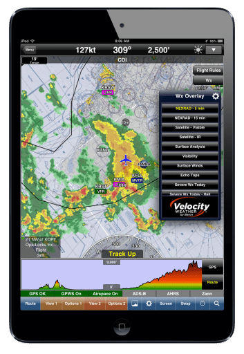
WingX Pro7 integrates Baron Service’s advanced weather with its moving map. Weather information is tailored to the pilot’s planning and flying conditions. By using a settings pop-up, pilots can change the weather transparency, change the animation rate, and even change the weather resolution to reduce download bandwidth requirements, according to company officials.
WingX Pro7 offers a selection of Baron’s weather information, including NEXRAD, Visible and IR Satellite, Echo Tops, Surface Analysis, and Contoured Surface Wind Speed.
WingX Pro7 Version 7.0 also gives pilots the ability to view their route and breadcrumb trail on approach charts. Pilots can add waypoints and fixes using ChartTouch directly on the approach chart and see their route line updated immediately on the approach chart.
With Version 7.0, WingX Pro7 also adds pitot-static support for the experimental market.
For more information: HiltonSoftware.com