By JEB BURNSIDE.
It’s way too early to know what happened to cause early July’s mid-air collision between a Cessna 150 and a U.S. Air Force F-16C near Moncks Corner, S.C.
The accident is being investigated by the NTSB, but it’s likely the pilots involved were where they were supposed to be, doing nothing unusual. Both aboard the Cessna died, while the F-16’s pilot safely ejected and reportedly was uninjured. Both airplanes were destroyed.
Regardless of the investigation’s outcome, it’s not too early to highlight some things about military flight operations we all should know, but sometimes omit from our flight planning. We know about military operations areas (MOAs) and restricted areas, for example, but it appears the collision occurred outside such airspace.
Media reports mention the F-16 pilot was engaged in some form of instrument training. I know next to nothing about F-16s, but it’s unlikely its pilot was shooting approaches under the hood in a single-seat fighter. Instead, it may have been on a published military training route (MTR), which are easy for civilian pilots to ignore. In fact, an instrument MTR is charted very near where the the two airplanes apparently collided.
Quick Review
All kinds of stuff goes on in the U.S. military’s special use airspace and the vast majority of it is unhealthy to civilian pilots, unless you enjoy things like live-fire exercises, bombing practice and mock dogfighting up close and personal. An MTR, meanwhile, is for conducting low-altitude, high-speed training. How low, and how fast?
Below 10,000 feet and in excess of 250 knots is the official word, but an MTR can be flown below 1,500 feet AGL and at more than 300 knots, perhaps a lot more. At those speeds and altitudes, no one has much time to react, or many places to go when they do.
The Aeronautical Information Manual sums it up in a classic understatement: “The required maneuvers and high speeds are such that they may occasionally make the see-and-avoid aspect of VFR flight more difficult without increased vigilance….”
And since they’re routes rather areas, an aircraft using one literally is a moving target. Each MTR can be up to 16 nm wide — eight nm either side of the centerline — and they come in two flavors, visual and instrument, and are used both day and night. A visual MTR, or VR, is the type extending below 1,500 feet AGL — to as low as 100 feet — while instrument routes, IRs, use that same 1,500 feet AGL as a minimum altitude.
Charting
Charting of MTRs can be deceptive. Instead of a vivid splash of color telling pilots “here be fast-moving dragons,” a relatively narrow, gray line is used on sectionals and a brown one on low-altitude en route charts.

Figure 1 depicts MTRs throughout the Continental U.S. — outlined in red — courtesy the See and Avoid website (SeeAndAvoid.org), which is jointly funded and operated by the FAA and the Air National Guard.
Figures 2 and 3 depict how MTRs are charted on sectionals and low-altitude en route charts, respectively, zoomed in on Moncks Corner.
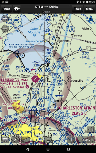

If one zooms in even more on the airspace near the Berkeley County Airport (KMKS) in Moncks Corner, as in Figure 4, an MTR identification — IR18 — is visible within the smaller yellow circle.

The charting denotes an instrument route and the arrow indicates it’s designed to be flown from the south to the north. In other words, if we’re departing KMKS to the east, it likely won’t do us much good to look for high-speed military traffic to our left; it’ll be coming from the right side of the aircraft, perhaps from behind us.
The larger yellow circle of Figure 4 highlights two additional points. The first is how IR18’s charting is partially overlaid by a divided highway, also depicted running roughly north-south right next to the KMKS airport.
The second point is how close IR18 is to KMKS. In other words and given an MTR’s maximum width of 16 nm, the possibility exists of a military aircraft blowing through the VFR traffic pattern at the Berkeley County Airport, and presumably others, at more than 300 knots.
Resources
Even if you have a current sectional, there’s no guarantee it accurately depicts an MTR. That’s because MTRs are revised on a 56-day cycle, while new sectionals come out every six months.
According to the FAA Aeronautical Chart User’s Guide, pilots are “cautioned and advised” to check with Flight Service for dimensions and status of MTRs along a proposed route. The User’s Guide also advises that changes in charted MTRs will be “indicated in the Aeronautical Chart Bulletin of the Airport/Facility Directory.”
On low-altitude en route (IFR) charts, all MTRs except those VRs entirely below 1,500 feet AGL are depicted. Since these charts are updated every 56 days, it’s likely they show the present MTR alignment.
Also, the depictions on low-altitude en route charts allow users to distinguish between narrow and wider MTRs: Those with a total width of five nm or less are shown by a 0.02-inch line, while wider ones use a 0.035-inch line. That distinction really is important only if you’re using a paper chart, since electronic charting allows us to zoom in and out, making the line’s width difficult to determine.
Aftermath
At this point, it’s not at all clear the F-16 was using IR18 when the mid-air occurred or if it was on some other sort of training mission. It’s also not clear at what altitude the collision occurred, whether ATC was involved in monitoring either airplane, or if the 150 even had a working transponder.
It is clear that MTRs can be an oft-ignored factor in our flight planning, however, and it might be a good idea to re-think how and where we look for traffic while airborne. I know I will.
I read the report. I’m a GA VFR pilot. I fly in the New York airspace under the bravo. It’s a beehive. N07. When I get out into open space i get flight following, In my opinion, It would have been best if the 16 turned immediately to 180 as instructed by ATC. Seems to me that would have avoided the whole incident. Simple. I don’t expect to be hit by a 16 or a Dash 8 moving at 250 knots or better while I’m in the pattern. Really, and even if I saw the blurr, how fast can I, myself and my c-172 react? This collision was avoidable. As all are. Very sad. But another learning opportunity to be safer pilots. Be well and be safe.
In the early 1960’s my dad was flying an Ag-Cat from Oklahoma to Nebraska. Somewhere over Kansas he was suddenly flanked on each side by a pair of very fast moving F-101’s. He always figured they had him on radar and were just practicing by making a deliberate pass at him. After reading all of the above – maybe he was just lucky.
I have read the entire preliminary report numerous times.
Both aircraft had their transponders on. Both aircraft were OK in what they were doing until…
ATC advised the F16 of traffic. ATC again advised the F16 of traffic and told them to turn 180 to the right if he didn’t have them in sight. ATC gave the F16 ample warning. But he did nothing. He disobeyed ATC, or at least ignored his advise.
It wouldn’t matter if the two aircraft were at 7,000 feet.
Wouldn’t matter if they were on a “route”, or in a MOA. The 150 had every right to be where he was, doing what he was doing and was following all the rules. The F16 chose to ignore ATC and it cost the two in the 150 their lives and probably the F16 pilot’s career.
What you can take out of this is, not just to be vigilant near “routes” and MOA’s but if ATC tells you something, take action then and there. Don’t wait, the results can be rather unpleasant.
I challenge anyone to tell me one thing they would have done differently if they were the 150 pilot that would have made a difference and they do in the real world.
It is most inappropriate here to infer that either the F-16, or the C150, or ATS was necessarily at fault. They were all likely following their standard procedures and protocols, each trying to do their best, at what they were trying to do. The weakness here is the obsolete and antiquated ATC system, and the fundamental concept of VFR VMC, that is never going to solve this issue in its present configuration or form, especially as the UAV threat increases.
This F16 was not on a training route. It was a simple vector for a practice approach, just like any other airplane. His speed was 250kias. Nothing outrageous. Stop the speculating already.
Well spoken ATC. Further, even if the F-16 was using his radar (which is quite good in the Block 50), it may not have even seen such a slow moving target due to the radar’s deliberate doppler notch. So we just need to find out the facts, when the investigation has been completed, and in the meantime, stay vigilant, and realize that the days of VFR VMC flying into a hazy sunsets is likely to itself sunset, as we move toward EFR for all airspace, so as to be able to safely and economically still be able to afford widespread airspace access in the future.
Ya, right. Watch for the screamin eagle coming up your 6 at 300+ knots. I’ll do that! Why not keep the military training ops inside the military training areas?
I agree. They already hog enough airspace. Too many times I waste time and FUEL as I am routed around their area ( wait…..who owns it ?) when NOTHING is going on with training; many times it si solid IFR !!! Use the outrageous amount of space they have already claimed !!!
I did read the released prliminary report, and it did provide a transcript showing that ATC DID advise the military pilot of the traffic, and DID advise a route change twice that the military pilot didNOT do.read the transcript.I did fly out of Moncks corner several years ago, with a local instructor, and was cautioned about the MOA airspace nearby. There isn’t a whole lot of room there.
Couple of key points to bring up in everyone’s mind as a military fighter pilot who also flies and has flown a lot in the General Aviation world. VR routes are going to be more dangerous than IR, we are going to be lower 100′-1000′ and at least 350 knots more. So while we have a radar we can only check it every 3-5 seconds as we are more concerned with not hitting the ground, which could only take 1-2 seconds to happen. Please cross all VR routes 90 out and at least2000′ AGL in non-mountainous terrain and 3000-5000′ AGL in Mountainous terrain. Our RADARs may or may not see you based on your aspect and what your aircraft is made out of, cloth and wood aircraft are especially difficult. Our maneuvers on these routes are very dynamic so most of our time is spent looking outside and not at our RADAR and I agree with the comment above about a possible illusion or inability to see the other aircraft when he does not have any lateral movement in your field of vision. It happens all the time in our business and we have lost many good aviators to it.
Maybe it is time to mandate that TCAS/ADS-B systems be installed on these military aircraft to force situational awarness upon them. They are dynamically manuvering at high speed in aircraft intentionally painted in a way to make visual detection difficult.and their solution is for us to be more careful in THEIR airspace. Keep in mind those military aircraft come with ejection seats and they are usually the only survivor of these encounters. Just think how many military aircraft could receive such safety upgrades for the cost one one brand new F-35.
Most military aircraft have either TAS/TCAS or some type of radar for exactly this purpose. We’re always on the lookout for bug-smashers flying on the LL routes.
I think he means so that we can see the fighters on our radar/tis and not just them seeing us.
It was many years back, probably in the 70’s or 80’s but there was a collision between a Beech Baron and an F-4 that has always sent chills up my spine. The pilot of the Baron was being an idiot and on returning from the Bahamas did not stop and clear customs but instead flew on up the coast some ways off shore. The times being what they were a pair of F-4’s was dispatched to identify the intruder. One F-4 returned to its base shortly after takeoff because of radar problems bu the other pressed on and attempted an intercept in IFR conditions. The rate of closure was so high that when the F-4 got the Break-Off indication on radar due to close proximity the aircraft impacted the Baron in a high bank atttitude. When the F-4 got back to base and they started looking at the damaged wing they found a rudder hinge bracket, a nut from the back of a pitot-static instrument in the instrument panel and smears of human blood and tissue. As I said at the start the Baron pilot was being an idiot but the intercept was far from perfect and the Baron occupents paid the ultimate price. If any survived the impact I can barly imagine the horror they experienced prior to impact with the ocean, probably not unlike what the two completely innocent occupents of the Cessna in the story related above. Aircraft of such different preformance capabilities should not be mixed at the lower altitudes. And just wait until Amazon and others take to the air with their package delivery drones !!!
Why are jets scrambled so close to civilian airspace anyway? In IFR conditions? Seems like overkill. Send a light twin to intercept and ID… save a few bucks, save a few lives, don’t act like bullies. Easy does it. Who are you protecting anyway?
What in the world are you talking about, Matt Mason ?? Could you define “civilian airspace” for me, please? And,… ” Why scramble JETS ?? Who are they protecting ??” …. YOU,,.. you idiot !! How old were you on 9/11/2002 ?? Sorry kid,.. a twin Cessna can’t power up and get to a TOI (Target of Interest) 200 miles away, in a matter of minutes. Not to mention,.. they’re not very intimidating or formidable aircraft to an enemy combatant. And none of this has anything to do with the accident in question.
Oh I don’t know for sure, but I don’t foresee a big threat coming from the shores of the Bahamas.. enemy combatants? really? The soft touch strategy is better… kinda like the Mayberry RFD policing policy vs. jackboot bullies. We could always “scramble” interceptors if needed. Use intel, not retards.. hopefully mutually exclusive. And on a personal note, I have spent more time living on AFB’s in this country than I’d like to admit… I was also standing on my balcony on W57th street looking south on 9/11 with coffee in hand. I have also been rushed by “homeland security” while at sea and had “fast-movers” fly up my backside around Key West… both totally unnecessary… tighter controls need to be on military ops in this country… please DON”T protect me and remember to thank ME for providing you that cool helmet. -taxpayer
What I want to know is how can a modern fughter aircraft with a sophisticated radar system for detection and engagement of targets ever not know it is about to run into another aircraft ? If they are screaming along at low altitude and high speeds should they not utilize this unique resource to provide protection against mid air collisions ? The USCG put a version of the F-16 radar into their now mothballed HU-25C aircraft just to locate and track small aircraft trying to sneak into the USA from other parts. If they can find a Cessna then this guy should have if he bothered to use that expensive system we bought for him to play with. If they are going to engage in hazardous operations imune from the FAR’s then I think they should put more effort into protecting us tax payers from the danger they represent.
It’s called physics. That’s why.
It is probably time for the software teams (ForeFlight, WingX, Garmin Pilot, and others) to start incorporating IR and VR into the synthetic vision displays. The information regarding the active width and height of these routes could be downloaded as they are updated with notices provided in the programs when new data is available.
As an old, bold, and not dead yet bold pilot, I can add one thought. I submit, that a VFR pilot flying sans transponder just might be invisible to other aircraft at altitude. Here’s why; another aircraft, flying against an open sky background is virtually invisible to another pilot unless it is transposed against a contrasting and semi-stationary background. The reason: focal point.
One time, flying near Edward’s Air Force Base (legally) a passenger said, “Look at that that.” I said, what? I looked again, and searching the horizon I saw it, another aircraft at a slightly lower altitude.
Another time I was flying to San Diego and out of Santa Ana USMC Air Station two Phantom jets rose slowly toward me. They passed within 500 meters. I doubt if they ever saw me.
The point is, I really doubt military speed is to be blamed here – maybe just happenstance. Being in the wrong place at the wrong time.
“The second point is how close IR18 is to KMKS. In other words and given an MTR’s maximum width of 16 nm, the possibility exists of a military aircraft blowing through the VFR traffic pattern at the Berkeley County Airport, and presumably others, at more than 300 knots.”
Sorry, no possibility of this exists on this route. This particular route is defined as only being from 5000′ MSL to 7000′ MSL. (This info is tougher for the GA pilot to find, as the AP1/B isn’t widely distributed, but FSS should be able to pass it along.)
Also, the reason MTRs are several miles wide is so the pilot can maneuver to avoid hazards within the route lateral limits, whether they are airports or towers. No military pilot is going to callously blast through an airport traffic pattern at high speed just because it is within the lateral confines of a MTR route.
All airports located on or near low level routes are usually avoided by at least 1500′ and 3NM at all times by any military aviator,
Similar issues in our very dense airspace in The Netherlands. Maybe military traffic should only be allowed to exceed certain speeds (e.g. > 250 kts) when monitoring traffic ahead with their on-board radar. In addition, we now all carry the mandatory Mode S transponders, which squitter own positions regularly. See-and-Avoid is therefore enriched with many additional options, let’s start using these to the max.
I love articles like this. It really helps keep a pilot proficient in the many other aspects of flying that aren’t stick and rudder skills. Keep it up!