The transition to graphical forecasts for aviation (GFAs) for the continental U.S. is set to be complete Oct. 10, 2017, when the current textual area forecasts (FAs) will be discontinued.
The move, in a transition phase since July, is expected to result in improved weather information from forecasters with the National Weather Service Aviation Weather Center, according to FAA officials.
“The majority of the weather elements contained in the FA are already available through other NWS products,” agency officials said in a notice highlighting the change. “To maintain continuity of service, the GFA will ensure the availability of equivalent information, in addition to adding graphical displays of the predominant weather, sky cover, and wind speed and direction.”
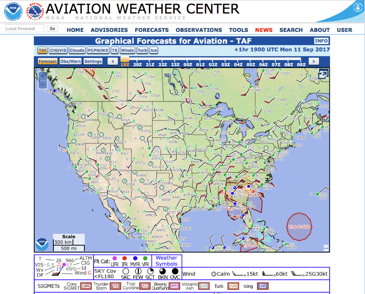
GFAs are web-based displays that provide observations and forecasts critical for aviation safety. GFAs cover the continental U.S., from the surface up to 42,000 feet mean sea level (MSL).
Wind, icing, and turbulence forecasts are available in 3,000-foot increments from the surface up to 18,000 feet MSL, and in 6,000-foot increments from 18,000 feet MSL to 42,000 feet MSL.
Turbulence forecasts are also broken into low (below 18,000 feet MSL) and high (above 18,000 feet MSL) graphics.
Maximum icing and maximum wind velocity graphics are also available. Data is time-synchronized and is available in hourly increments for up to 14 hours in the past and 15 hours into the future.
“This is a huge step forward,” says John Kosak, Air Traffic Services project manager for weather for the National Business Aviation Association. “The graphical forecasts provide much finer resolution than any text-based forecast ever could.”
Kosak represented general aviation and business aviation as a member of the FAA’s Collaborative Decision-Making Weather Evaluation Team.
The GFAs will replace the textual FAs only for the continental U.S. The FA for Alaska, the Gulf of Mexico, Hawaii and the Caribbean will not change.
Finally!!! When I began flying in 1970, my instructor took me to a teletype machine in the flight planning room and said that its purpose was to provide us with weather info. With that, an update began to appear on this machine that clanged and banged as it barely printed to what appeared to be 20 lines of typos on a huge roll of what seemed like toilet paper. At least it had a nice yellow hue to it. I took one look at the report and asked my instructor, “What the hell is this”? He replied, “That’s your weather report”. I said, “But I can’t read it. It looks like the Dead Sea scrolls.” He laughed and indicated that I would have to learn it. So I tried and never could grasp all of it and of course, low and behold, a sample of that gibberish was a question on the written test. My whole attitude toward the report in this format was, “This is f——–ing stupid”. And guess what? The format actually discouraged me from checking weather and I based my go no go decisions more on weather TV broadcasts and calling flight service stations. This change is very welcome and way over due. My analogy is that with having gone from the Abacus to personal computers in everyday life, it has been really stupid to hold on to this Abacus of weather reporting for so long. It took too long, but better late than never—I guess.
What about Cloud Tops?
Congratulations on this!
This is probably the single most important contribution to general aviation safety in decades. We finally have a clear, easy to understand weather map which is light years ahead of the antique teletype distribution system so beloved of buggy whip manufacturers and whale oil refiners.
Now I can SEE what the weather will be instead of trying to decipher cryptic abbreviations and try to laboriously construct a “forecast” (a/k/a “best guess”) by examining the entrails of goats (and remember, these need to be certificated goats, any old goat won’t do – it is aviation!)
It also makes my job as an AGI tremendously easier. No more trying to pound this obsolete, arcane drivel into the heads of my poor students, now all they have to do is look at the picture and get everything they need!
This is good news indeed!