A review of ADS-B data revealed the Super Petrel LS departed Hickory Regional Airport (KHKY) in North Carolina, about 1120. The airplane flew northeast toward Lake Hickory at an altitude of about 1,600 feet mean sea level (MSL) and a groundspeed of about 98 knots.
After arriving over Lake Hickory, the airplane turned left to the west and descended to about 900 feet MSL before the ADS-B data ended.
About that time, a witness recorded the airplane performing a touch-and-go landing on the water.
A short time later, several other witnesses observed the airplane flying “unusually low” and “in a highly banked angle” over the water.
Another witness, who was on his boat dock about 100 yards northwest of a set of energized powerlines that spanned the lake, reported the airplane flying level about 100 to 200 feet above the water toward the powerlines.
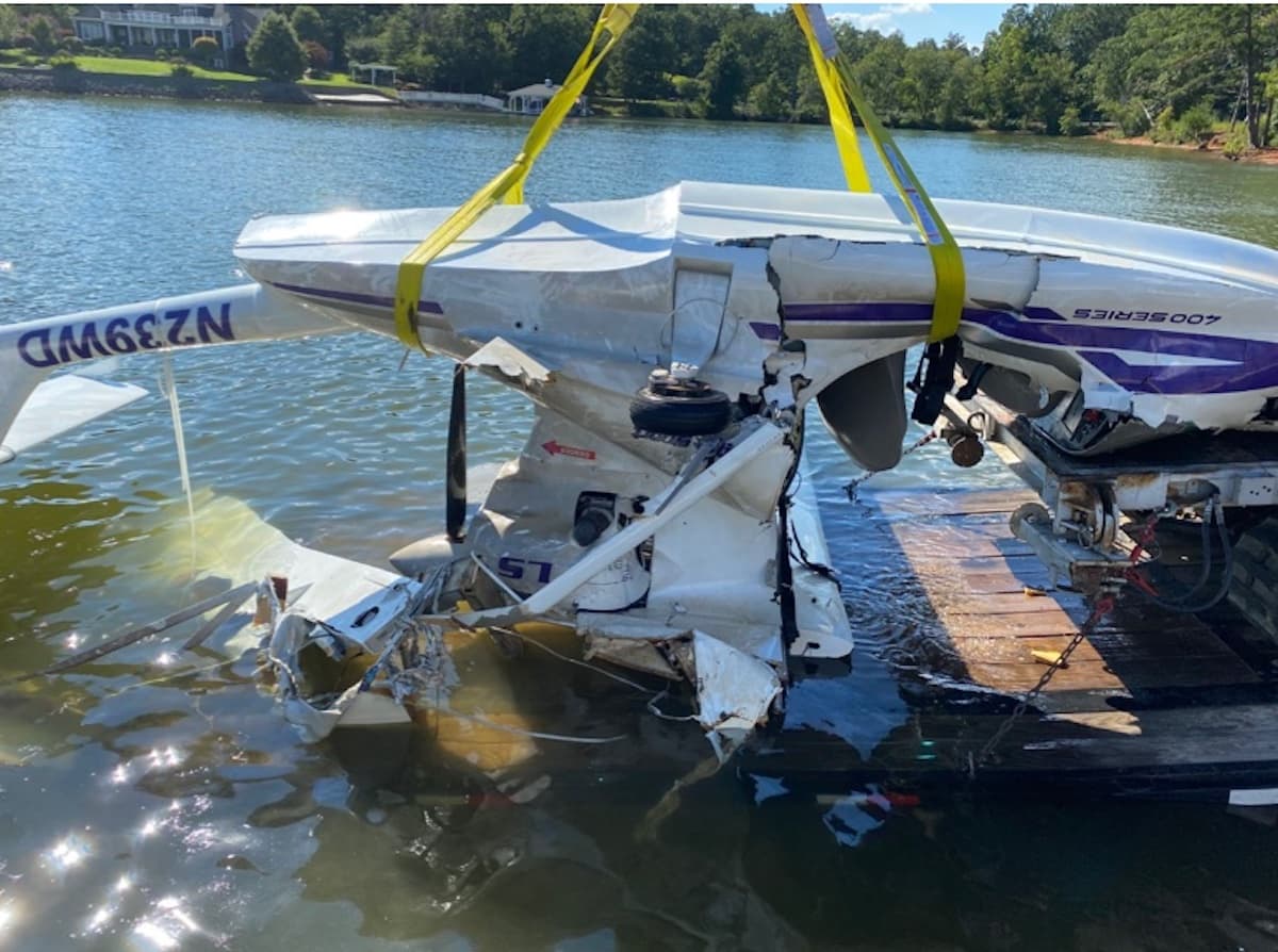
As the airplane approached the powerlines, it appeared to take a “sudden” nose-down attitude before it hit the powerlines. There was an explosion and the airplane then tumbled into the water.
The collision with the powerlines resulted in a power outage to the surrounding community of 18,000.
The private pilot, who was the owner of the airplane, and a student pilot passenger died in the crash.
Post-accident examination of the airplane revealed the plexiglass windshield/canopy was missing due to impact damage and the entire cockpit area was exposed. Striations consistent with contact with a powerline cable were observed embedded on the left side of the dashboard. Deep gouging and striation marks were also observed from the top left area of the fuselage out toward the left-wing root and continued down the left side of the fuselage.
The left wing had separated from impact and the composite material (fabric) was melted and shriveled along the inboard portion of wing. Heat-damaged wing material was also observed hanging from where the wing had separated from the airframe. The right wing had been removed by salvage personnel and did not appear to be damaged.
The tail section remained attached to the airplane, but the left horizontal stabilator was deflected down from impact. Flight control continuity was established for both horizontal stabilizers by manual manipulation of both control sticks. Continuity was confirmed to the wing root area for both wings when the control sticks were moved. The rudder pedals were partially jammed due to impact, but some movement was achieved to the rudder when the pedals were manipulated. A light coat of soot was observed on the engine pylon, cowling, spinner, and portions of the fuselage.
The engine remained secure to the airframe and was undamaged. The three bladed propeller remained secure to the engine and all three blades were secure in the hub. The outer half of one blade was missing and the remaining portion of blade exhibited some gouging. The other two blades were intact and exhibited gouging. The engine crankshaft was manually rotated via the propeller. Thumb compression and valvetrain continuity were established to each cylinder. Fuel and some water were noted in each carburetor bowl.
Power and transmission lines are typically not published on an aeronautical map unless they are over 200 feet tall and then only used for navigation. No altitudes are charted for individual towers and their depiction is intended to help navigation by pilotage or using visual landmarks outside of the airplane. The FAA designated these in the Aeronautical Chart User’s Guide as “power transmission and telecommunication lines.”
Probable Cause: The pilot’s failure to maintain clearance from powerlines while maneuvering at a low altitude over water, which resulted in a collision and loss of control.
To download the final report. Click here. This will trigger a PDF download to your device.
This August 2023 accident report is provided by the National Transportation Safety Board. Published as an educational tool, it is intended to help pilots learn from the misfortunes of others.
Were the power lines properly marked?
Another very common accident
It keeps happening………
I wondered the same. No pictures of the powerlines, no pictures of orange balls, etc. Yet in mountainous areas, I see these High Tension lines with large “balls” around the cables to make them visible. And here on a body of water where “sea planes” can operate, Duke didn’t “flag” these lines to make them more visible?
The power lines pass over Waterfront Dr. Street view will give a view from directly underneath the power lines and you can zoom east to view the power lines over the water. I don’t see any markers on the lines. There is a black line on the Atlanta sectional passing over the lake that appears to be the same power lines. As the report says there is no altitude information given for power lines. This is located within the current Hickory Regional Class D airspace but it may have been a non-towered airport on the accident date as I didn’t see any references to ATC.