The pilot told investigators that the Cessna 152 encountered “extreme” turbulence while on the approach to an intermediate stopover airport during a night cross-country flight.
She extended the downwind leg of the traffic pattern at the airport in The Dalles, Oregon, to stabilize the airplane, and during the base leg turn, the airplane hit a wire and then hit terrain.
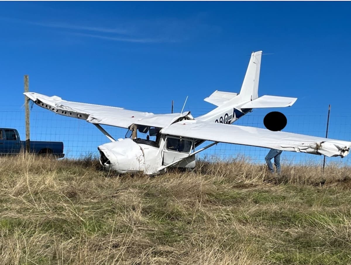
The airplane sustained substantial damage to both wings and fuselage, while the pilot sustained minor injuries.
The airport is located at an elevation of 246 feet mean sea level (MSL) in a major river gorge. The northern ridge line above the airport is about 2,900 feet MSL, and the southern ridge line is about 1,300 feet. The accident was located about 2 miles south of the airport at an estimated elevation of about 650 feet. High tension powerlines are positioned south of the airport along the southern ridge.
According to the United States Navy Observatory, the official sunset was at 17:12 Pacific daylight time (PDT), the official end of civil twilight was at 17:42 PDT, and the official moon set was at 20:02 PDT.
The night cross-county training flight was part of the pilot’s training curriculum for her commercial airplane single engine land certificate.
Probable Cause: The pilot’s encounter with severe turbulence at night which resulted in an extended downwind and collision with wires during the base turn.
To download the final report. Click here. This will trigger a PDF download to your device.
This October 2023 accident report is provided by the National Transportation Safety Board. Published as an educational tool, it is intended to help pilots learn from the misfortunes of others.
Night VFR into a 200′ elevation airport surrounded by 3,000-4,000′ mountains? Absolutely not. I feel like turbulence didn’t cause the accident. Unfortunately, the NTSB usually does a superficial investigation of nonfatal accidents.
Flightaware shows the pilot setting up for 2+ mile final and already below TPA on the extended downwind. A standard final for a C152 is 1/2 to 3/4 mile and a long final is one mile. Pinning the probable cause on turbulence is a cop-out. Pilot lost SA. Keep it tight at night, don’t turn your downwind leg into its own cross-country.
Perhaps it’s an elevation, not an evaluation? : “at an estimated evaluation of about 650 feet”
Oof. Thank you for catching that error Javier. The text has been updated.
Need strong prevailing ambient conditions in a plane that’s virtually at the mercy of everything. Rode on a 152 once on a night flight with a friend. Quite impressed that we flew, and flew, and flew…and I could still see the airport through the omni-vision rear window.
Looking at the terrain, obstacles, dark night, weather and winds I would have given a hard no. Looks like a breakfast flight to me, training or not. An important thing to learn is when to say unable or unnecessary.
Turbulence did not bend the aircraft………… that headline is a false statement……
Turbulence apparently caused the PIC to make certain decisions
The PIC certain decisions put the aircraft in the same airspace as the wire
I agree the GAN title is absolutely misleading. By the same token, I think the NTSB’s “Probable Cause” wording is way off base, and the pilot’s Form 6120.1 “Narrative History of the Flight” begs more questions than it answers. As you pointed out, the turbulence didn’t bend the airplane: Hitting a wire and smacking the ground did.
Flying conditions in/near the Columbia River gorge can quickly turn from silky smooth to brutal, especially on the east end near KDLS. Dark conditions out there can make it challenging even when it’s calm. There are several issues I’d quiz the PIC on:
– A “circling descent” 15nm south, at night, over that area? Not me.
– Pattern entry: Direct to a ‘45’ or overfly the pattern first?
– Did you have divert fuel back to KRDM?
– Did you even have a Plan B?
– “I attempted to keep the airplane straight and level while also attempting to turn for the base leg”? What did that look like; airspeed, configuration, etc …?
– Pitch black, on instruments with no visual reference outside …but continued attempting a VFR traffic pattern. Why?
– Who should you probably call first (if able) following an ‘incident’?
Glad her experience got HAA’s attention.
She was incredibly lucky.
There’s a power line shown on the sectional at a perpendicular angle approximately two miles south of runway 31 and a single tower obstruction in the accident area of 810ft msl, 563ft above the airport which is about a 2.5 degree angle to the runway, close to a normal 3 degree angle. There are other power lines shown in all directions from the airport. The instrument approach from the south has an MDA of 1320ft msl. For a night vfr cross-country and visual approach, that airport presents significant challenges.