

According to a friend, the pilot and two passengers departed Juneau International Airport (PAJN) in Alaska, on a flight bound for the Yakutat Airport (PAYA) in the Beech A 35 on July 20, 2024.
The friend alerted search and rescue personnel when the airplane was two hours overdue.
An FAA alert notice was issued and search and rescue crews were dispatched to the last known point on the airplane’s route, however poor weather conditions hampered the search.
According to ADS-B data, the airplane departed Juneau about 1344 and initially headed northwest for about 72 miles. The airplane’s track then changed direction to a southwesterly heading and began flying through the mountainous terrain of Glacier Bay National Park for an additional 30 miles.
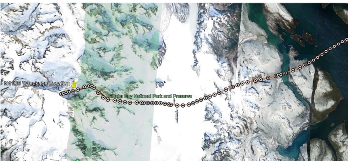
About 1421, as the airplane’s flight track continued along a westerly heading of 245°, at an altitude of 10,875 feet MSL, and with a groundspeed of 141 knots, the flight track abruptly ended on the eastern side of East Crillon Mountain. The elevation of the terrain above the last data point was about 11,220 feet.
The down-sloping terrain on the eastern side of East Crillon Mountain consisted of expansive vertical rock, snow-covered terrain, and hanging glaciers, with areas of widespread glacial crevasses directly below.
The closest weather reporting station, located in Gustavus, Alaska, about 54 miles southeast of the accident site, reported at 1356 that the ceiling was overcast at 600 feet above ground level (AGL) variable to 1,100 feet, with 10 miles visibility.
A preliminary NTSB weather study showed Aviation Weather Center Graphical Forecasts for Aviation data indicating cloud bases as low as 2,200 feet MSL and tops no lower than 12,000 feet in the accident region, with surface visibilities less than 0.25 statute miles.
The High-Resolution Rapid Refresh (HRRR) model, provided by the National Oceanic and Atmospheric Administration (NOAA), suggested the presence of clouds from 3,000 feet MSL to 12,500 feet in the accident region. The National Weather Service had issued an AIRMET for mountain obscuration in the accident region.
The United States Coast Guard, Alaska Air National Guard, and Civil Air Patrol conducted extensive search and rescue efforts in the area surrounding East Crillon mountain.
Search personnel reported finding what was believed to be an initial impact site, marked by a V-shaped upslope terrain disturbance near the last known ADS-B data point on the accident airplane’s flight track. The site was in an area of very steep, and in some areas vertical, snow- and ice-covered terrain. The area around the airplane’s suspected initial impact site appeared to have had recent avalanche activity, which would have carried any airplane wreckage downslope.
Search and rescue crews deemed the suspected initial impact site as inaccessible due to the high elevation, significant avalanche danger, and inclement weather.
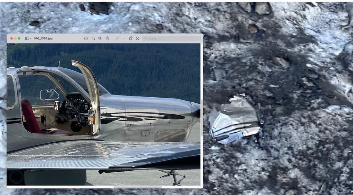
On Aug. 5, an aerial search of the accident site and the surrounding area revealed portions of highly fragmented airplane wreckage on the eastern side of East Crillon Mountain about 6,260 feet MSL. The portions of wreckage were found more than 4,500 feet below the suspected initial impact site, and spread out over an area of rough, steep, and crevasse-covered glaciated terrain.
Portions of the fragmented wreckage were identified as belonging to the accident airplane by comparing photos of the airplane’s distinctive paint scheme with photos of the wreckage. The pilot and two passengers had perished in the accident.
Global Data Assimilation System model soundings for near the accident were retrieved from NOAA’s Air Resources Laboratory and analyzed by the RAwinsonde OBservation (RAOB) program. RAOB noted scattered clouds about 2,800 feet, with broken to overcast cloud layers above that to about 13,000 feet around the time of the accident.
The freezing level was identified at 9,900 feet and the potential for light rime icing was identified between about 10,000 and 12,000 feet.
An AIRMET advisory SIERRA for “mountains occasionally obscured by clouds/precipitation,” with no change expected during the AIRMET’s valid period or the six-hour period beyond that, was issued by the Alaska Aviation Weather Unit and was valid for an area that included the accident site at the time of the accident.
An Area Forecast for the region was issued before the time of the accident. This Area Forecast included the AIRMET information, and for the area south of Eldred Rock forecast few clouds at 300 feet, scattered clouds at 1,200 feet, ceiling broken at 3,500 feet with cloud tops to 12,000 feet, and occasional ceiling broken at 1,200 feet with light rain showers. No significant turbulence or icing was forecast.
A review of the pilot’s flight logs indicated that the last recorded actual or simulated instrument flight time occurred more than five years before the accident. No additional instrument flight time was logged after that date.
Maintenance records showed that, at the time of the accident, the airplane had not undergone the inspections required under Federal Aviation Regulations for instrument flight. Additionally, there was no evidence that the pilot obtained a preflight weather briefing from an official source.
Probable Cause: The pilot’s decision to continue the visual flight rules flight into instrument meteorological conditions, which resulted in controlled flight into terrain.
To download the final report. Click here. This will trigger a PDF download to your device.
This July 2024 accident report is provided by the National Transportation Safety Board. Published as an educational tool, it is intended to help pilots learn from the misfortunes of others.
Training w less than 3k’ ceiling is one thing, but flying a XC to another airport with less than 3k’ is certainly, IMO, an iffy proposition.
Yes; ignorance can kill you.
I still tell my students this, “you can search all of the dictionaries of all of the languages on earth, and you will still not find one word that will alibi you if you run out of gas in an airplane.”
“When it’s a weather related accident, they always bury the pilot on a nice, sunny day.”
Weather presents hazards for any pilot. Spatial disorientation, optical illusions, low/zero visibility and possibly icing, any or all of which can kill you. Even marginal VFR can be a serious threat. If you’re not IFR rated AND current, avoid, avoid, avoid. Another thought for those of us flying single engine airplanes: how comfortable are you flying into low IFR without a spare engine? As for me, not very. I have many hours of IFR flying, all in multiengine jets. It’s a different world IMO with only one powerplant. Have some realistic personal minimums. For me, IFR is for en route travel. If the motor quits, I want time below the clouds to find a place to put the airplane. 1000/3 are my mins. Mountain obscuration is an absolute no go. YMMV.
LT’s remarks on fuel are equally relevant. Please, please, please acquire a fuel stick calibrated for the airplane you fly. If the tanks aren’t visually full, know exactly what you have! Wing tank fuel gages are notoriously inaccurate when the quantity gets below 30% or so. Simple math – time and fuel flow – is your friend. Running out of gas is incredibly embarrassing and potentially fatal.
LT’s comment cannot be any more spot on and are very concise in noting the reasons these types of incidents keep occurring in the general aviation community over and over and over!
For starters you can’t fix stupid! No VFR pilot should be flying unless you have 3000’ bases and 5 miles visibility. Simple. Sure the regulations say you can go with less, but usually we end up reading about you. Two things would cut the accident rate in half, first stop running out of gas, amazing some can’t read a fuel gage or do simple math? Second stop flying VFR into IFR conditions. No one should ever die in a plane, mostly boils down to taking chances, bad attitude, poor training and not practicing enough. Be safe!
LT, I once was flying at an airport where I was doing my flight training, a solo flight. The airport was known for rapidly changing conditions, and I was turning crosswind when I saw the fog rolling in. It was coming behind me on the downwind, and it was soon down to 3.1 miles. I was not at all comfortable with 3.1 miles; 5 wouldn’t have been much better. I might add I was a student pilot at the time, and I have to say that my minimum – despite the school’s rule for me of a 5 mile minimum – was 10 miles.