

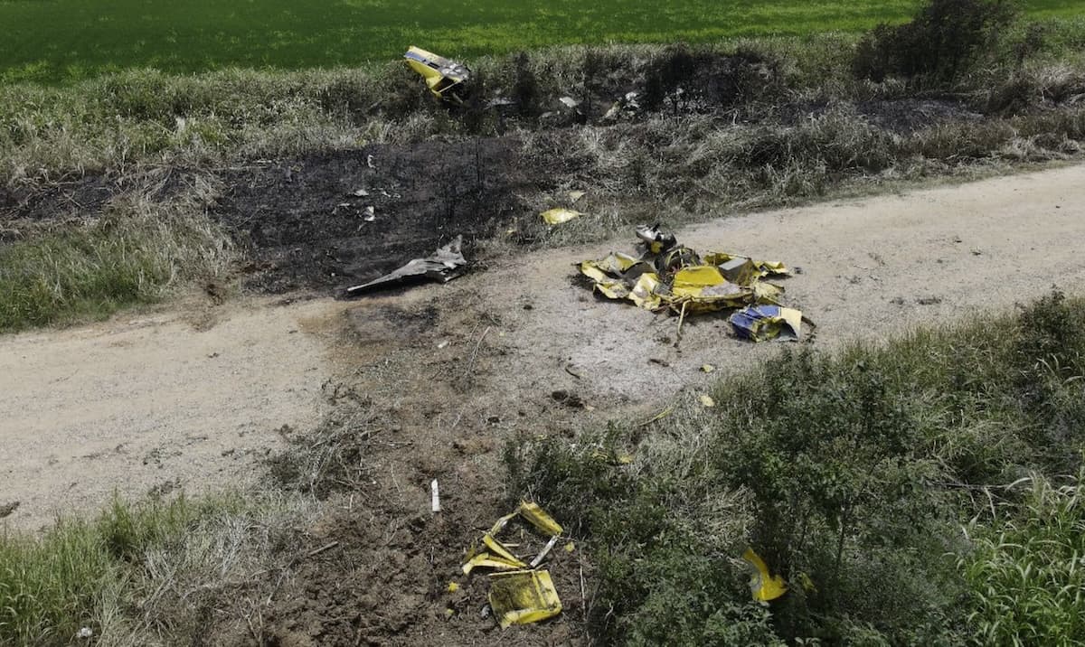
According to recovered data and witness information, an Air Tractor AT-802A, N795LA, departed a company airstrip about two miles west of the collision site in Bonita, Louisiana. The planned flight was to provide aerial application to a field about 12 miles east of the airstrip. An Air Tractor AT-502B, N6177J, departed a company airstrip about three miles northeast of the collision location and the planned flight was to provide aerial application to a field about 10 miles southwest of the airstrip.
According to the pilot of N795LA, he departed the private airstrip and was traveling east about 200 feet above ground level. About two miles after departure, he observed N6177J about 100 feet to his left at the same altitude.
The pilot of N795LA pulled back on the control stick to avoid N6177J. Shortly after, he felt an impact and heard a bang, but was able to control the airplane after the collision. He circled the area, noticed N6177J had hit the terrain, and observed a small ground fire. The pilot of N6177J died in the crash.
Due to the unknown damage to his airplane and with the airplane being loaded with chemicals, he decided to complete his aerial application flight. He then returned to the airstrip and landed the airplane with the tailwheel landing gear missing from the airplane.
A witness, who was the loader for N795LA and located at the company airstrip, stated that he observed N795LA take off from the airstrip and fly east, as planned. Above a distant tree line, he observed N6177J transitioning from the northeast to the southwest and then the collision between the two airplanes. He observed one airplane descend into the terrain and then saw smoke, while the other airplane continued in flight. Shortly thereafter, N795LA returned to the airstrip.
According to the operators of both airplanes, neither pilot provided radio communications during the flights.
N6177J was equipped with a Satloc M3 Bantam aerial guidance system and N795LA was equipped with a Satloc G4 aerial guidance system. The M3 device and the G4 data files were sent to the NTSB Vehicle Records Laboratory for download and analysis of the data.
The data revealed that N6177J departed the airstrip northeast of the accident site about 1352 and started to travel toward the southwest. N795LA departed from the airstrip west of the accident site about 1353 and started to travel toward the east. N6177J’s data ended at 1353:32 in the vicinity of the wreckage. The data revealed N795LA continued to an application area to the east before returning to land on its originating airstrip about 1406.
Based on the relative positions of both airplanes, as N795LA was on its easterly heading, N6177J would have been at about the pilot’s 11 o’clock position. Simultaneously, about 30 seconds before the collision, as N6177J was flying on the southwesterly heading, N795LA would have been about the 1 o’clock position.
Just before the collision, the data from N795LA indicated it was at 175 feet altitude and about 125 miles per hour groundspeed. N795LA was in a consistent gradual climb after takeoff, and N6177J’s altitude varied between 100 and 150 feet after takeoff. N6177J’s data ended about 20 seconds before the collision (the device manufacturer indicated that if the device abruptly loses power during an accident, up to 30 seconds of data stored in a volatile buffer may be missing from the data stored on the internal card).
A post-accident examination of the accident site revealed N6177J was highly fragmented, and the debris came to rest in wooded terrain, on a gravel road, and in adjacent ditches. The outboard 6-ft section of N6177J’s left wing was separated and came to rest in the wooded terrain. The separated wing structure exhibited a semi-circular impact and black rubber transfer marks, consistent with the size of N795LA’s main landing gear tire. N6177J’s left horizontal stabilizer, about mid-span and mid-chord, was deflected upward and exhibited a mark and black rubber transfer mark, consistent with the size of N795LA’s tailwheel tire.
The underside of N795LA’s spreader exhibited yellow paint transfer marks and shards of paint and fiberglass, consistent with N6177J’s left wing tip. N795LA’s tailwheel and fork were found in a rice field about 750 feet east of the estimated collision location.
N6177J’s 3-blade propeller assembly remained attached to the engine propeller shaft and forward compressor section. The 3 blades were bent aft, twisted in the direction of rotation, and all 3 blade tips were separated.
N6177J was equipped with standard navigation and strobe lights on the wing tips and empennage. In addition, the forward fuselage (nose) contained two pulsating LED lights. N795LA was equipped with standard navigation and strobe lights on the wing tips and empennage.
Probable Cause: The failure of both pilots to see and avoid the other airplane while at low altitude enroute to their aerial application flights.
To download the final report. Click here. This will trigger a PDF download to your device.
This July 2024 accident report is provided by the National Transportation Safety Board. Published as an educational tool, it is intended to help pilots learn from the misfortunes of others.
ADSB OUT AND IN. amazing how some think it’s a waste of money. Could have saved these two. I’m glad some spray outfits in my area are using them. See and avoid only works to a point. Once you have ADSB it’s hard to fly without it.
It’s Amazing what ADS-B In shows that is never seen out of the windshield. It’s unbelievable that pilots still choose not to equip and use it.
I’m feeling he should have circled the crash site and radioed for help in case the other pilot was still alive. I understand his concern about damage to his plane and the chemicals on board, but we’re talking about a human life here.
Speaking for myself, I would have been too upset to be able to complete my aerial application flight after hitting another plane, and circling over the crash site. There is no mention in the article whether or not he even radioed in the incident to anyone.
This was at almost 2pm, so I wonder if sun glare might have prevented N6177J’s pilot (flying SW) from seeing the other plane.