

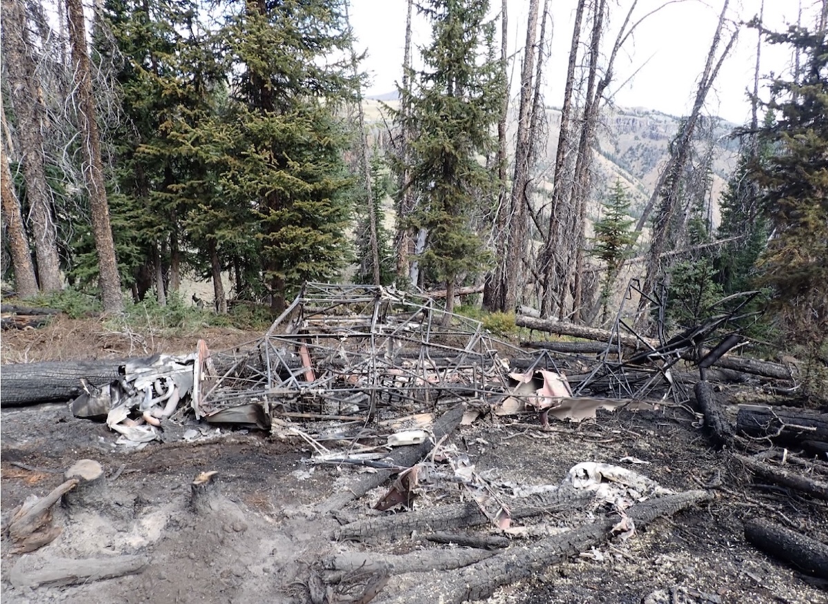
The 78-year-old widow wanted to spread the ashes of her recently deceased husband over Franc’s Fork in the Shoshone National Forest in the mountains southwest of Cody, Wyoming, so she contacted the pilot, who was a friend of her husband, to enlist his assistance.
Naturally, he agreed to help.
On the day of the accident, the widow was his passenger. The pilot had been given a GPS waypoint by the family, which he navigated to, although based on the spaghetti-like ground track of the flight, it would appear that he had some difficulty finding the spot. Later, while he had no recall of the accident or the events immediately leading up to it, he did tell investigators that he “maneuvered at various headings and altitudes looking for the GPS point.”
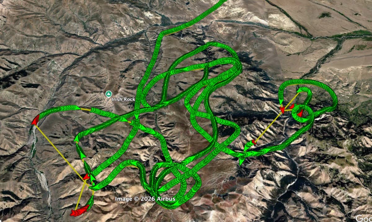
That said, he ultimately struck pay dirt, and “observed” the family gathered on the ground below. He circled and the ashes were deployed. On the ground the family saw the airplane overfly their location “several times” then depart to the west.
Mission accomplished.
The family headed back down the mountain, and into the nearest town, Meeteetse. As they proceeded toward town, emergency vehicles were heading in the opposite direction. At the time, they had no way of knowing that the first responders were headed for the crash site of the very airplane that had just dropped the ashes of their departed loved one.
A crash that would rob them of yet another loved one.
The Airplane and The Pilot
The airplane was an American Champion 8GCBC Scout, the utility cousin of the Decathlon and Citabria. Light weight and powered by an 180-hp Lycoming O-360 engine, Scouts are often utilized as bush and mountain airplanes.
The 65-year-old private pilot was a male, flying on BasicMed. Somewhat unusually, his NTSB 6120 form notes a limitation on his BasicMed: “Not valid for night flying or by color signal control.” Limitations aren’t a normal part of the BasicMed ecosystem, so it might be that the pilot checked the wrong box on the form or it might have been a limitation on his medical prior to his adopting BasicMed. Either way, it suggests he had some degree of color blindness.
He had 1,029 hours total time, over half of it in tailwheel airplanes, with 116 in make and model. He was a Wyoming resident, so this was home turf for him.
The Accident
Exactly what transpired following the ash drop isn’t clear. The last recollection of the pilot was that after the drop, he rolled out on a heading and applied engine power, but that, quoting the NTSB record of their conversation with him, “the airplane reached an altitude where it would not climb, and the airspeed was near stall speed. He did not recall the altitude the airplane was at when the airplane would not climb any further.”
The Scout crashed into mountainous terrain, along the south edge of a valley. Based on the satellite images, the valley, while not being a box canyon exactly, is definitely a dead-end street if you don’t have the right altitude.
Investigators later charted the first point of contact: A 150-to-175-foot-tall tree. From that point, a debris path only 200 feet in length on a rough heading of 210° magnetic led from the tree to the main wreckage. Various portions of the flight control surfaces and propeller fragments — along with damaged trees and branches — littered the path.
The fuselage came to rest upright, then the airplane was consumed by a fierce post-impact fire.
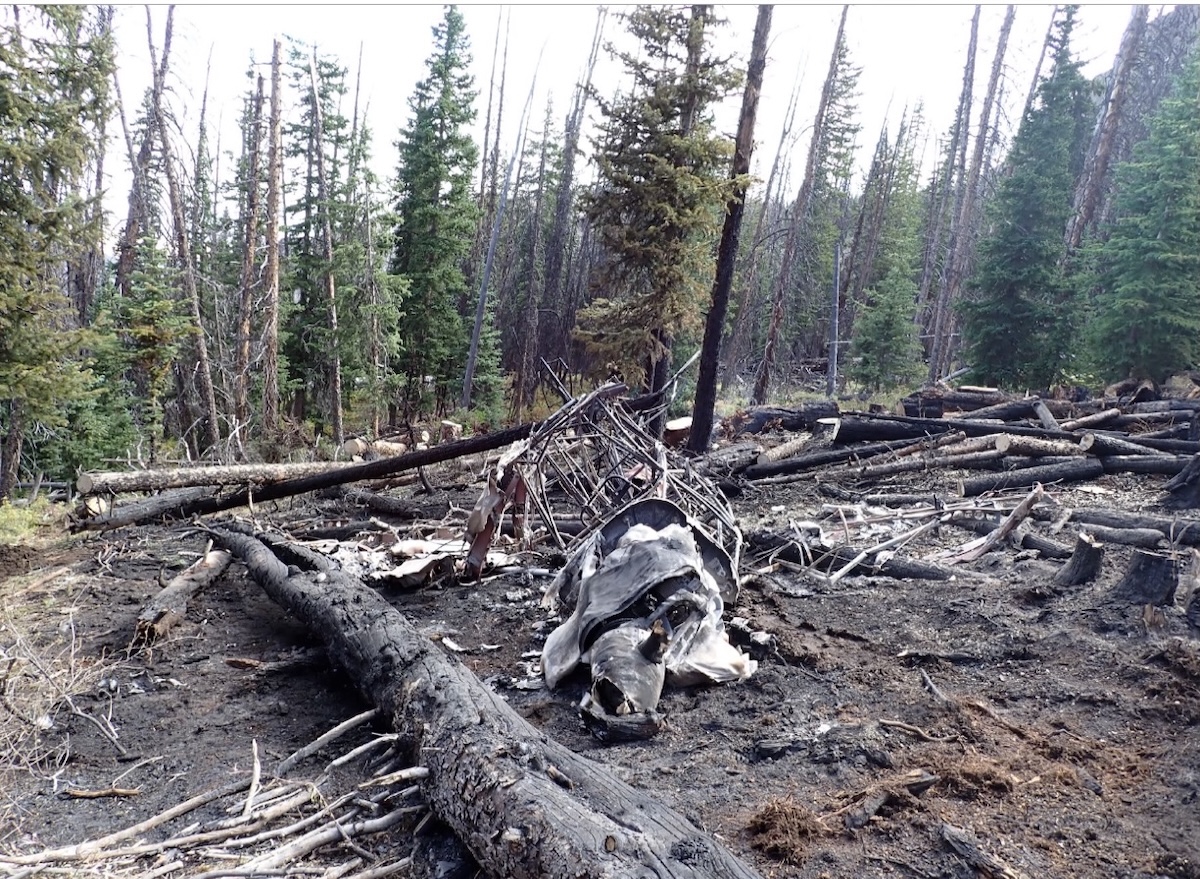
Two men hunting nearby actually heard the crash, which they described as a “loud bang.” They then observed a rising column of black smoke about three-quarters of a mile from their location. They scrambled to assist, contacting EMS on their way.
When they reached the accident site, the airplane and the surrounding area were in flames. They found the pilot — who was seriously injured — outside of the airplane “near the fire.” They dragged him clear and rendered first aid. While waiting for the first responders the pilot told the hunters that he did not know what had happened, but that there was another person aboard the airplane.
It was the widow, who died in the crash and the Viking funeral that followed, her ashes mixing with those of her late husband in the clear mountain air.
Gut wrenching. Yet perhaps darkly romantic, in some cosmic way? Fully Shakespearean, at any rate.
The NTSB
One of the hunters, who was a pilot, said he first heard the sound of a “sputtering engine” before the loud bang. But the NTSB ruled out engine failure as a factor in the crash based on two lines of logic, writing, “the witness report of a sputtering engine could not be corroborated due to the extensive thermal damage from the post-crash fire,” and, additionally, that “ADS-B data indicated that the airplane continued to climb until the collision with rising terrain.”
I wouldn’t say that just because there was so much damage that you can’t prove there was a problem means there wasn’t one, but I do agree that the fact the airplane was climbing into its crash site suggests the engine was producing more than sputtering power.
The NTSB investigators also ruled out carb ice, given the atmospheric conditions.
In the end, the Probable Cause statement reads: “The pilot’s decision to continue the flight over rising terrain at a low altitude in a high-elevation, high-density-altitude environment.”
This last bit was determined even though the NTSB investigators showed the aircraft had a service ceiling of 14,500 feet, and they calculated that, given the conditions and weight of the airplane, it should have been able to deliver a climb rate between 549 and 679 feet per minute at the pressure altitudes it was flying through.
Analysis & Discussion
There are more things that don’t add up here for me. Looking at the columns of raw ADS-B data on the NTSB Docket, the recorded pressure altitude (PA) of the last reading before the crash was 9,000 feet. But earlier in the flight, there is sustained flight at a PA of 10,900 feet, nearly 2,000 feet higher and it appears he successfully cleared higher terrain earlier in the flight more than once.
So what do we make of that? It has me scratching my head.
There is one possibility that comes to my mind when looking at the NTSB’s data.
But, first, for those of you not (yet) trained in mountain flying, here’s what you need to know about mountain flight: It’s not really a horsepower thing. Few GA engines can outclimb the mountains of the American West.
Mountain flight, instead, has more in common with sailplane flying than with other kinds of flight. It’s about understanding where to find lift, both mechanical and thermal. And it’s about understanding where “sink” lurks.
Looking at the accident track, I noticed that for the final two-and-a-half miles or so, the pilot was flying along the north side of a valley. That’s a good call that time of year, as the north valley slopes are soaked in sunlight, making them lift generators. But right before the crash, as the canyon turns, he switched more toward the center of the valley, and the NTSB tells us that the crash site is on the south side of the valley, which would have had less sun and less lift.
Why did the pilot switch sides? Maybe he had no choice. While it looks like there was room to stay on the sunny side, looking at ADS-B overlays on Google Earth doesn’t give us any sense of the cockpit view. Maybe he didn’t have the turn radius, or didn’t feel he had the radius, to stay to the north and make the bend.
But what has me scratching my head even more is the flight path itself. Especially the final legs. The family reported that the airplane headed west after the drop and we can see that’s correct by looking at the track of his flight. But west is into the heart of the mountains and not the way back to Cody.
Worse still, the track actually shows that after the drop, he had skimmed over a couple of peaks and had made it out of the rough terrain and was actually out over the flatter land between the forest and Cody before turning and heading deeper into the mountains again.
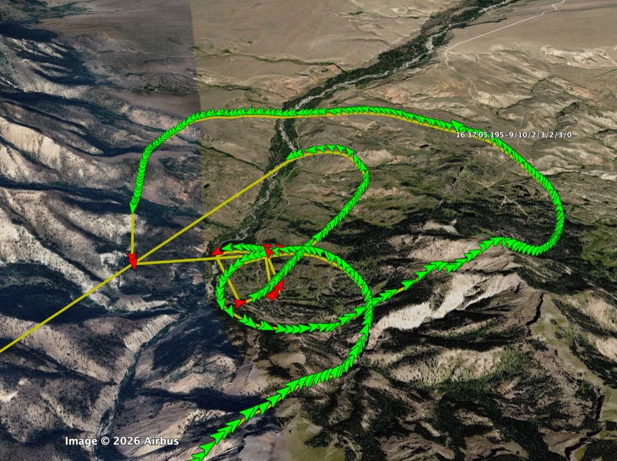
Why would he do such a thing? Was he disoriented? Was it a navigational error? Hypoxia? Did the widow ask to fly into the mountains one more time? We will never know.
But there is one other interesting tidbit on the NTSB docket that may — or may not — have had anything to do with the accident, and that’s found in the NTSB weather analysis.
This report noted that for the most part, the weather featured “light winds” and “clear sky” over the surrounding area, but also included this nugget: “A sudden deterioration in visibility in haze was noted after the accident with surface visibility as low as ½ mile. The restriction was not expected.”
Although the drop in visibility to IFR conditions wasn’t recorded until about two-and-a-half hours after the crash, the recording is from the airport in Cody, nearly 40 miles away, and at a much lower altitude. Could the visibility have dropped in the mountains earlier?
It’s interesting to speculate, but it could well be a red herring. The hunters didn’t mention it, nor did the pilot recall or relay any concerns about visibility to investigators.
The Takeaway
So what can the rest of us take away from this Shakespearean Tragedy? How can we be sure the next play is a history or even a comedy?
Two things, I think. The first is that with mountain flight, your relationship to slopes with lift and slopes with sink must always be your top priority. You need a constant moving map in your head, much like the way you keep track of other aircraft in a busy untowered traffic pattern.
And second, we know from statements from both the widow’s and pilot’s families that the flight to the GPS location and the drop were planned the day before — although the flight track suggests it was more challenging to execute that plan than expected.
But I have to wonder: Was an exit strategy part of the plan? Perhaps it was. But if not, with all the twisting and turning flight amongst many peaks and valleys, a second GPS location — a homing beacon if you will — might have averted tragedy.
So as part of your pre-planning your way into anything, especially in the mountains, be sure you also pre-plan your way back out again because, to be honest, I’m not really a fan of Shakespeare — and don’t want to read another one of his aerial tragedies.
The Numbers
Want to read more? Download the NTSB’s final report here or view the items on docket here.

Could be carbon monoxide. Aimless wandering and incapable of tracking go to on the gps.
True. But would the post crash medical exam of the pilot indicate that? Maybe not post fire.