

Like many readers of General Aviation News, I started flying when Non-Directional Beacons (NDB) were common. The Automatic Direction Finder (ADF) featured prominently in our cockpits and a watch was essential equipment that verified how long a pilot had held a particular heading. GPS hadn’t been approved for general aviation use yet.
Inflight weather radar was a fanciful dream that only existed in big iron.
Looking out the window was a primary navigation tool for us — as it still is for VFR pilots. As it should be. But just looking out the window isn’t good enough sometimes, especially when convective activity is on our route of flight.
Technology has brought a great many benefits to our instrument panels. Initially quite expensive, but over time the cost came down even as the practicality of these devices improved. Better service for fewer dollars. I like that trend. Many of us do. An assumption I feel comfortable making as I see the plethora of Electronic Flight Bags making their way into cockpits of even the most basic aircraft.
But there’s a price to be paid for all this convenience. Over the past few decades we didn’t just adapt to new technology. We became dependent on it. Slowly, and perhaps unintentionally, but we’re there.
Too many pilots are too heads down too often.
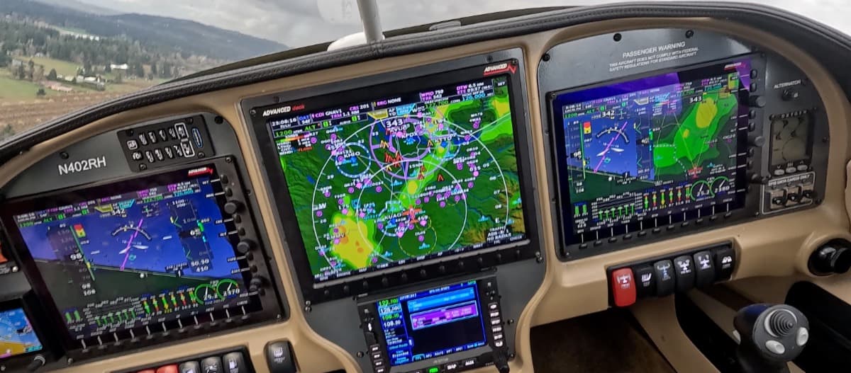
It is no secret the Society of Pilots Who Blindly Follow the Magenta Line now exists: Men and women who are glued to a course line depicted on a device on their lap or in the panel — too often with little to no interest in where they actually are along that line.
That’s risky behavior even if it is a convenient way to lessen the workload of cross-country flying.
Just this morning I read a social media post from a pilot who lost his electrical system in flight. No GPS. No radio. No lights. For a pilot accustomed to a set-it-and-forget-it style of navigation, that’s a perilous moment.
Safety isn’t an accident. It comes with planning, preparation, and the availability of good information we can make use of in the cockpit.
This was on my mind when a note fell into my lap from my friend, Ingram Leedy. Ingram is a commercial pilot and aircraft owner with a real passion for aviation. He’s also one of the smartest, most technologically proficient people I’ve ever known. If Elon is a 10 and I’m a 2, Ingram is a 9 on the techno-geek scale.
When Ingram speaks, I listen. And Ingram is concerned.
His note was specifically about the information being fed to us on our various boxes via our multitude of subscription services. Or, more specifically, information that is not being provided. Information that is available, but not delivered. That caught my attention.
Couple that question with the risks associated with flying one of the most densely traveled international air routes general aviators fly and we can easily see there’s a problem brewing. One that deserves the attention of anyone who stretches their legs to travel beyond the boundaries of the contiguous 48 States.
Thousands of aircraft fly between the U.S. and the Bahamas annually. Many do so with instrument panels equipped to provide valuable weather information. Information that is critical to the safety of flight. That information is provided via subscription services specifically intended to enhance the safety of general aviation pilots and passengers.
But does that information actually exist? Yes. Of course it does. Radar originating from Miami reaches almost all the way to Andros. Bahamian radar covers the islands well. But does it get to your cockpit? No, it probably doesn’t.
Sirius XM publishes a map that defines its service area. That map includes all of the Bahamas and Cuba. It falls just short of covering Haiti and Jamaica. That map is often misunderstood to be a description of where radar service is available. It is not. Rather, this is a depiction of the satellite signal footprint, not the radar coverage.
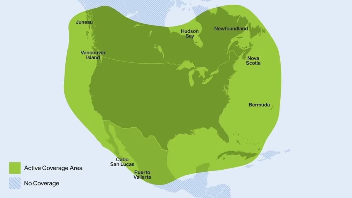
Starlink is a global provider, which may suggest to pilots who subscribe to the general aviation plan that they’ve got coverage well beyond the borders of the U.S. Unfortunately, they may not. The basic plan cuts off at the 12 nm limit from the coast.
An Ocean Mode option is available, although it is not included in the basic plan. Ocean Mode must be toggled on prior to leaving the 12 nm limit and remains active until it is toggled off. Throughout that time, billing runs at $6 per GB. That is a price increase that goes into effect on Sept. 27, 2026.
Radar information that covers the Bahamas is available to people on the ground. It is likely not available in the cockpit, however — where pilots need it most.
This is the question Ingram raised. The concern I find most compelling is this: If radar information is available — and it is — and if the aircraft has the ability to display that information — and they do — how can we get that life-saving weather radar into the cockpit most expediently?
The answer to that question may rest on the level of motivation pilots and subscribers feel to reach out to their various providers to pose the question: When can your service begin to provide the safety-oriented information I need most when I fly outside the 12 nm limit? When will the weather radar available to ground pounders be available to me in flight?
Market pressures are often an effective means of inciting change. Is there any more profoundly pertinent market pressure than a multitude of customers making it clear they want a better bang for their buck?
Or we could go back to the ADF, the NDB, and looking out the window to identify risks as we run headlong into them.
I know my preference. Writing a letter to my provider would be a far more beneficial use of my time and energy.

I have had both XM Weather and ADS FIS-B weather in my plane. I actually dropped XM Weather as the price benefit was not good enough after ADS FIS-B became available. That is not true for everyone of course. There are several trade-offs.
Years ago I remember watching the local Cable TV RADAR at home or at the hotel, driving to the airport, no TV with RADAR at the FBO which I though strange. I’m sure some FBO’s had it.
The issues you speak of are not technical, they are cost related. The current tech and cost is pretty reasonable balance in general. Of course we all remember if you want to use RADAR for tactical decisions, you should add real RADAR to your your plane.
Thanks for this, Jaime. It led me to research the differences in latency between FIS-B weather and XM. I didn’t realize there was such a large difference. Still not real time, tactical avoidance type of weather info, but much faster than FIS-B.
If you go back to NDB, remember that the ADF can help you see where the clouds are striking sparks.
I spent three and a half years as a Weather Observer with the Air Force and watched my job and the WX service decline from human action of Meteorology to what we have today. I am dazzled by what has happened to weather reporting today (before Trump). Yes, the electronic cock pit is full of more knowledge and getting easier to use than ever. The problem, as I see it, is the user’s ability to work with it. What I mean by that is what the atmosphere is doing or going to do the airplane’s needs. That, of course, is the pilot’s control. How many drivers have any taildragger time? Without warnings, power is an assumption. Got glider time? Use free time to have fun and learn. Drive a Pits, float for thermals. have fun and knowledge. Couldn’t hurt.